Photo credit: STRATUS
CropSat is a free precision farming tool developed in Sweden that leverages satellite imagery to optimize nitrogen fertilization, particularly for crops like wheat and other cereals. The tool uses Normalized Difference Vegetation Index (NDVI) data from satellite images captured every 2–5 days to monitor crop growth, biomass, and variability across fields. By providing tailored nitrogen application maps, CropSat ensures more efficient resource use, reducing both costs and environmental impact.
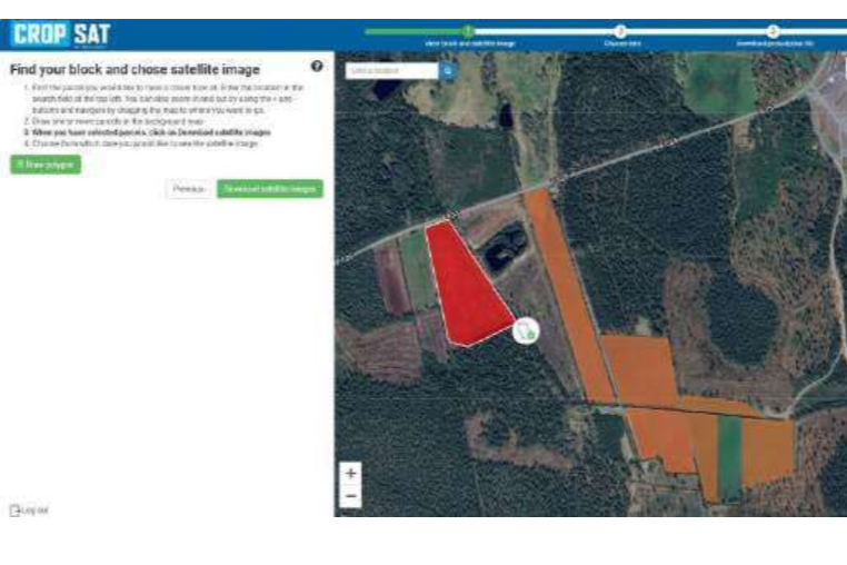
The process begins with farmers accessing the user-friendly CropSat web platform, where they can view their fields on an interactive map. The platform highlights variations in vegetation caused by
factors such as soil quality, water availability, or nutrient deficiencies. These insights help farmers identify underperforming zones that require targeted fertilizer applications.
To create Variable Rate Application (VRA) maps, the user follows these steps:
a)Satellite imagery identifies crop health and biomass variability, providing the basis for precise fertilization planning.
b)Farmers can generate application maps by selecting the field, crop, and the target nitrogen rate for specific zones. The platform allows users to input parameters like product type (e.g., mineral fertilizers).
c)Once the VRA map is created, it can be downloaded in ISO-XML or Shapefile format, ensuring compatibility with modern tractor guidance systems and variable rate spreaders.
d)The task map is uploaded to the tractor’s onboard terminal, allowing the equipment to automatically adjust nitrogen application rates in real time. This precision minimizes over-fertilization in healthy zones while providing additional nutrients where needed.
CropSat has become an essential tool for farmers because it improves yields, promotes sustainability, and reduces fertilizer costs. Unlike traditional methods, where nitrogen is applied uniformly using generalized recommendations, CropSat enables farmers to account for field variability. The approach addresses previous inefficiencies where some zones were over-fertilized, leading to unnecessary expenses and increased nitrogen leaching, while others were under-fertilized, resulting in reduced yields. Compared to alternative technologies like N-sensors, CropSat provides a more affordable and accessible option, as it does not require costly equipment. Additionally, it requires minimal technical expertise, making it suitable for farmers with a basic understanding of digital tools. All that is needed is access to the internet, a compatible variable rate spreader, and a tractor capable of processing task maps.
In terms of environmental impact, the precision offered by CropSat significantly reduces nitrogen leaching, contributing to improved water quality. This aligns with sustainability goals while enhancing the public image of agriculture. Moreover, the practice allows farmers to improve both crop quality and economic returns, fostering a sense of accomplishment in balancing profitability and environmental stewardship.